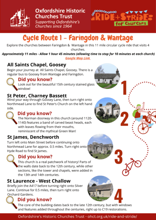
Explore the churches between Faringdon & Wantage in this 11 mile circular cycle ride that visits 4 churches. Approximately 11 miles – Allow 1 hour 45 minutes (allowing time to stop for 10 minutes at each church).
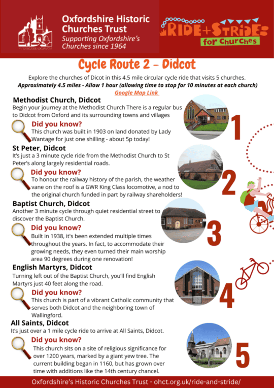
Explore the churches of Dicot in this 4.5 mile circular cycle ride that visits 5 churches. Approximately 4.5 miles – Allow 1 hour (allowing time to stop for 10 minutes at each church).
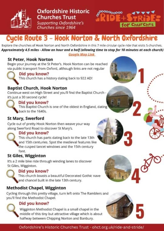
Explore the churches of Hook Norton and North Oxfordshire in this 7 mile circular cycle ride that visits 5 churches. Approximately 4.5 miles – Allow an hour and a half (allowing time to stop for 10 minutes at each church).
A walk of approximately 5 miles, which allowing (at least) 10 minutes per church can be completed comfortably within 3 hours, although a more in-depth visit could include longer spent in each church, a visit to Cogges Manor Farm, or a look round Witney.
A walk of just over 9 miles, from Folly Bridge to Radley via the Thames Path, crossing the river at the locks to visit St Mary’s Church, Iffley and St Andrew’s Church, Sandford on Thames, before the final destination of St James the Great, Radley. The walking time is about 4 hours, before adding on at least 10 minutes to look round each church, and perhaps more time to break for lunch at one of the pubs in Iffley or Sandford. There are also a couple of nature reserves adjacent to the Thames Path that would be worth stopping for. Or why not, when in Oxford, call into the Cathedral? This could easily be an enjoyable whole-day excursion.
A walk of around 6 miles, which allowing (at least) 10 minutes per church could be completed within about 4 hours, although the interest of the different churches, and of Burford itself, would repay a more in-depth visit. The walking is reasonably undemanding, with only a few stiles to negotiate on the path between Widford and Burford, and although there is a fair component of road walking the main stretch (Fulbrook to Swinbrook) is along a single-track lane with comparatively little traffic.
A walk of approximately six miles between Thame and Towersey, incorporating visits to their respective churches, can be comfortably completed in around four hours. However, the history and architectural interest of both churches and the charming town of Thame warrant a more leisurely exploration. The walking is gentle, with predominantly level paths and only a few stiles. While there are sections of road walking, the main stretch is along a quiet single-track lane.
A walk of between 4 and 5 miles (if done as a circular route, with an optional side trip to Besselsleigh), connecting three churches between the Thames and the A420 in what was once Berkshire. If as I did you start and finish by bus, beginning with Cumnor has the advantage that at no point do you need to cross the A420 on foot, something that needs to be done with care. Most of the route is easy walking; the only point to consider if taking the fieldpath route from Besselsleigh to Cumnor is that at one point after wet weather the path can be extremely muddy. (Even in a dry spell it is likely to be damp, although quite negotiable.) The walk can be comfortably done in between 3 and 4 hours, and with the Bear and Ragged Staff at Cumnor and the Greyhound at Besselsleigh there are possibilities for refreshment at each end.
A walk of approximately five miles that can be completed in around three hours, offering the pleasure and interest of an historic market town, two attractive and distinctive village churches, and the opportunity to visit a BBOWT nature reserve. The route offers the alternative of sticking to made surfaces (albeit with some road walking), or taking the footpath through the nature reserve. This makes for an enjoyable walk, but you need to be both mobile and sure-footed.
A walk around Wallingford, a market town rich in history. It would well deserve a little extra time for exploration, from the sections of Saxon burh walls that were once a defence against the Danes, to the remains of the Castle finally demolished by Cromwell (Wallingford was for centuries a key strategic crossing point). In between there are plenty of interesting buildings to look at in this historic market town, and eateries to enjoy.
For anyone who wants a longer walk, this route links to our ‘Downstream along the Ridgeway’, a route out of Wallingford running from Crowmarsh Gifford to North Stoke.
As usual, I got to Wallingford by bus: the X40 from Oxford is half-hourly, and takes about 50 minutes from Oxford High Street to the centre of Wallingford. But if you drive, there are good parking facilities. The relevant OS Explorer map is no. 170, ‘Vale of the White Horse’, and following the old county-boundary lines Wallingford is covered in the Pevsner/Buildings of England volume on Berkshire. (Crowmarsh Gifford and the other churches on the east bank of the Thames count as Oxfordshire.)
This is really a circular walk with two optional spurs. The route I chose was to use the excellent S9 bus service from Oxford to Wantage and walk from there to Childrey. At that point you can walk a further mile and a quarter west to Sparsholt and back, before bearing north-east to West Challow, and then following the course of the old Wilts and Berks Canal to East Challow. From there, it is slightly over a mile to walk back to Wantage. You might however choose to start from Childrey and walk the circuit from there, or begin and end at Sparsholt. I’d note that of course Wantage is in itself well worth seeing, including the splendid church of SS Peter and Paul (see our ‘Towards the Downs’ walking route). The OS Explorer 170 map for the Vale of the White Horse is particularly good for this walk; all the paths are well marked, and you can trace the line of the old canal that in its day was such an important means of transport. Walking as I did out from Wantage and back covers between six and seven miles; adding the side trip out to Sparsholt would take it to nearer nine.
Witney is both rural and urban: an historic market town, enriched by the medieval wool trade, which later expanded with the development of the mills that made ‘Witney blankets’ a world-famous product. A walk around its streets, visiting its churches and chapels, is both rewarding and enlightening.
The medieval Wychwood Forest once covered a broad swathe of West Oxfordshire, including the villages of Hailey, Ramsden, Wilcote and North Leigh. This walk of approximately 10 miles begins in Witney and runs via Hailey out on a curving route to North Leigh. From that point it is quite possible to walk back to Witney; alternatively, you can pick up the half-hourly S7 bus service (Witney to Oxford via Woodstock). The OS Explorer 180 map covers the area needed, and the footpaths are well marked. It is a versatile route that could be added to; from Hailey, for example, you could extend your walk to take in Minster Lovell before working your way back to Witney. From Ramsden, you could reach Finstock (perhaps to fit in with the timetable of the Witney to Chipping Norton X9 bus, which runs hourly Monday to Saturday, and two-hourly on Sundays.
I tested out this route in October, with an eye to winter walking: after a lot of rain, some of the paths that work well in summer may be flooded/seriously muddy in winter. I’ve therefore describe a route below that can be done walking along lanes/minor roads, but have indicated where the option of a path or bridleway is worth considering.
A walk of around 4 miles that can be comfortably completed in a morning, and that offers the opportunity to encounter some of the history of church building within the city, as well as seeing something of the development as a public space of the former Radcliffe Infirmary site, now the Radcliffe Observatory Quarter. The churches seen cover both medieval foundations and (as with the Anglo-Catholic glories of St Barnabas) examples of nineteenth-century ecclesiastical expansion, and each one opens windows on to both past and present.
A circular walk of between six and seven miles using lanes and a couple of fieldpaths (if you know the area, the distance could probably be trimmed slightly by using more footpaths, but I found walking the lanes very pleasant and straightforward). I found this an excellent route by which encounter some of the notable Ironstone churches of the Deddington Deanery: the churches described below make a wonderful introduction to the treasures to be found in this part of North Oxfordshire.
As a walker, I got to and from my starting point by using the local bus service, but you could also make a parked car the starting and finishing point. The map to use is OS Explorer 206, Edge Hill & Fenny Compton. The going is generally easy, and the only bit where you need to be surefooted is walking up to Drayton on a narrow path beside the A422. If you preferred not to do that (and visit Drayton separately directly from Banbury) it would be quite possible after visiting Wroxton to walk back to your starting point via Hanwell. As laid out here, the walk starts and finishes in Banbury where refreshments can be had, and there are pubs along the way in the villages visited.
A walk downstream along the Thames to the east of Wallingford, starting at Crowmarsh Gifford and finishing at North Stoke, calling in by the way on Newnham Murren and Mongewell two churches in the care of the Churches Conservation Trust (CCT). In general it is easy walking, although parts of the Thames Path can be uneven and slippery in wet weather (and don’t think of it if the Thames is flooded). This can be done as a single walk, or as an expansion of ‘A Wallingford Circuit’. The map to use is OS Explorer 170 ‘Vale of the White Horse’, and the official National Trail Guide to the Ridgeway is also useful. It is also worth remembering that the Pevsner/Buildings of England volumes split on the old county-boundary lines, so that while Wallingford comes under Berkshire, Crowmarsh Gifford and the other churches listed here are covered under Oxfordshire.
As usual, I got to Wallingford by bus: the X40 from Oxford is half-hourly, and takes about 50 minutes from Oxford High Street to the centre of Wallingford (or you can get off in Crowmarsh Gifford on the way in.) But if you drive, there are good parking facilities. Wallingford is also well supplied with places for refreshment.
Banbury is an excellent centre from which to begin to explore the splendid Ironstone churches of North Oxfordshire, but it is well worth visiting in its own right. Beginning in the fine town church of St Mary’s Banbury, a walk round a comparatively short compass will bring you to a range of extant and former churches and chapels testifying to the contribution the different denominations have made to their historic community.
Wantage, an historic market town, stands on the junction of two early routes, where the Reading to Cirencester road (the Portway) crosses the Hungerford to Oxford road. Centuries later, between 1810 and 1914, it was served by the Wilts and Berks Canal. Wantage was the birthplace (in 849) of Alfred the Great, and Alfred’s statue by the naval officer and sculptor Count Gleichen (1833-91), who was Queen Victoria’s nephew, stands commandingly at the centre of the Market Place, looking south where you can see the square tower of SS Peter and Paul, the parish church, rising above later buildings.
A walk round Wantage offers much to enjoy. Pevsner enthused over its brick Georgian houses, and in the nineteenth century the influence of the architect G. E. Street (a resident for two years in the 1850s), and the long-serving (1846-81) Anglo-Catholic Vicar of Wantage, W. J. Butler, added some lavish buildings. This is a town walk that can be enjoyed for itself, but which can also be linked up with two of our longer routes, ‘Towards the Downs’ and ‘Below the Ridgeway’.
Henley lies along the west bank of the Thames, and for centuries marked an important stage on the route between London and Oxford. From the late fifteenth century it had become a port for dispatching timber, corn, and malt by river to London, and by the late seventeenth century it had become a coaching halt between London and Oxford. It was a prosperous place, and that together with its proximity to the river meant that it increasingly developed as a resort centred on rowing. Walking round the town today, you can still enjoy the well-preserved buildings that remind you of its long history.
For some beyond the borders of Oxfordshire, the name today may be primarily associated with the outlet of ‘Bicester Village’, but Bicester is very much a town in its own right. Originally it was a settlement east of a Roman road running between Dorchester and Towcester. By the medieval period its parish church housed a shrine to the mysterious Saxon princess St Edburg, and an Augustinian priory was founded here in the late twelfth century. It was granted its own market in 1239, and an annual fair in 1252. It seems to have been commercially successful, and BoE comments on ‘general rebuilding’ in the seventeenth century. Major expansion came at the end of the twentieth century, and in 2014 designation as a ‘Garden Town’ indicated further increase, but through it all Bicester has retained its own identity. A walk round its churches and chapels is an excellent way to glimpse some of the key changes of past and present.
Headington, once a Saxon royal manor and then a village five miles from the centre of Oxford, has long since been embraced by the city’s eastward spread. At the end of the eighteenth century the main route from London to Oxford was re-routed from Shotover Hill to run through Headington, and significant building followed. The original village centre of ‘Old Headington’ is still recognisable, but the wider area is now closely populated and is home both to Oxford’s main hospitals and Oxford Brookes University. The different churches visited on this walk, from the medieval church of St Andrew’s Old Headington to the later nineteenth- and twentieth-century foundations, help build up a picture of a constantly developing community.
One of the pleasures of a town walk is that it can be as long or as short as you wish, while reliably offering interesting buildings within a small compass. Abingdon is a good example: a comparatively short walk links the mid-nineteenth-century elegance of the Baptist Church with the fourteenth-century painted ceiling of the Lady Chapel in St Helen’s, but you can then easily range more widely to take in the Abbey Gardens housing what is left of the great medieval Abbey of Abingdon, or walk north up Oxford Road to find the Roman Catholic church of Our Lady and St Edmund. Explore further to visit other town churches (the route below has an extension to Christ Church and All Saints, Methodist). And if you would like to add the rural to the urban, follow the Ock River Valley Walk down to Drayton, or think of crossing Abingdon Bridge, and walking downstream along the Thames Path to reach Culham, or Sutton Courtenay.
A 21-mile journey, taking around 4-5 hours, this route combines historic churches, picturesque villages, and scenic countryside. Starting at St. Mary’s Church in Cogges, this leisurely cycle tour explores the charming villages of Witney, Curbridge, Brize Norton, Swinbrook, Astall, and Minster Lovell. The terrain is generally easy to moderate, with some gentle hills. Note: While the route is generally straightforward, there are a few road crossings, particularly at the A40. Exercise caution and dismount if necessary for safety.
Please note, this route has been submitted by a Ride + Stride Participant and has not been tested by Ride + Stride organisers.
This cycle ride offers two route options: a 20-mile or a 23-mile loop, visiting between 17 and 18 churches. The terrain is mostly easy with a few hills. For the 23-mile route, leave the churches at Newland and Woodgreen until the end, while the 20-mile route follows a different order through the Witney churches. Both routes take you through picturesque countryside, with stops at historic churches in villages like Ducklington, Yelford, and Bampton. Enjoy a relaxed ride, and, if following the longer route, perhaps a break at The Lamb in Crawley before completing the journey.
Please note, this route has been submitted by a Ride + Stride Participant and has not been tested by Ride + Stride organisers.
This cycle route covers between 13 and 23 miles, depending on your choice to complete the full loop or return earlier. Starting in Witney at St. Mary’s, Cogges, and passing through a mix of easy terrain and a few hills, the ride takes you through historic churches in Witney, North Leigh, Long Hanborough, Freeland, and Eynsham. If you opt for the shorter route, you’ll cover 13 miles and visit 15 churches before heading back. For the full 23 miles, continue on to South Leigh, finishing with a total of 19 churches. Refreshments can be found in Eynsham, with a pleasant ride back to Witney.
Please note, this route has been submitted by a Ride + Stride Participant and has not been tested by Ride + Stride organisers.
This scenic circular cycle route through the Shrivenham and Ashbury Benefices links nine historic churches across peaceful villages and rolling countryside. Starting and ending at St Swithun’s in Compton Beauchamp, the route passes through Ashbury, Bourton, Shrivenham, Watchfield, Longcot, Fernham, Baulking, and Uffington, before reaching Woolstone and looping back. Along the way, riders enjoy quiet lanes, charming pubs, and views of open fields
This enjoyable circular cycle route starts in the village of Pyrton – though you can join at any of the churches along the way. Riding at a steady pace with only brief pauses to take in each church will take around an hour, but if you prefer a gentler ride, allowing time to appreciate the views and explore the buildings, plan for 1.5 to 2 hours. The route winds mostly along quiet country lanes. The only busier section is the B4007 between Watlington and Lewknor, where you’ll encounter more traffic for a short distance.
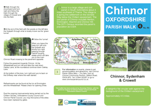
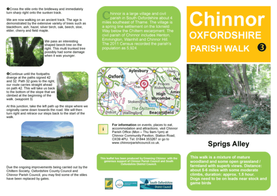
This flat and leisurely circular walk begins in the large South Oxfordshire village of Chinnor, set beneath the dramatic backdrop of the Chiltern escarpment. Chinnor’s history stretches back centuries as a spring line settlement along the ancient Icknield Way, and today it encompasses the hamlets of Henton, Emmington, Wainhill, and Chinnor Hill.
Covering around 4.5 miles, the route offers gentle walking with wide views of the hills above and the surrounding countryside. The walk begins at the roundabout where Mill Lane meets Estover Way. From here, follow Mill Lane until you reach the Driftway track. Just beyond the Driftway housing estate on your right, take the footpath that runs alongside the estate, leading you out into open landscapes and the start of your journey.
This ambitious full-day cycling adventure takes in an impressive 39 churches across Oxfordshire, covering around 60 miles in total. Winding through a variety of landscapes – from quiet country lanes to bustling town centres – the route is a true test of both stamina and curiosity, offering a rich tapestry of architectural styles, history, and countryside views along the way.
While designed as a challenging all-day ride, there are several points where the route loops back towards itself, making it easy to shorten if you prefer a more manageable distance. Whether you ride it in full or select a section to enjoy, the experience is as much about the journey between the churches as it is about the stops themselves.
If riding with a group, it’s worth remembering that stopping to explore each church adds significantly to the day. Even a brief 5-minute pause at each site adds up to an hour for every 12 churches visited. Solo riders, aiming for quick 2-minute visits, may find it easier to keep within the day’s schedule – but for many, the extra time spent admiring the buildings is part of the joy of the challenge.
One of the delights of this South Oxfordshire circuit is the way it threads together riverside villages, quiet hills, and bustling market towns, each with churches rich in history and character. Begin in South Stoke, where St Andrew’s 13th-century tower watches over the Thames, then head to Ipsden’s St Mary the Virgin, a tranquil hilltop church with links to St Birinus himself. From there, the route flows on to Dorchester Abbey’s soaring spaces and Wallingford’s varied treasures – from the intimate Quaker Meeting House to the ancient tower of St Leonard’s, witness to centuries of change. Whether you ride the full loop or stroll a section, this is a journey through a thousand years of faith and community, with each stop offering its own story to discover.
This beautiful circular walk around Sprigs Alley offers a mix of mature woodland, open farmland, and sweeping Chiltern views. Starting with oak and beech woods, the route leads you through tranquil valleys, along uneven bridleways, and past carpets of spring bluebells in beech and holly woodland. Look out for Red Kites overhead, ground-nesting birds in the fields, and the striking vista of the Stokenchurch telecoms tower in the distance. At around 5–6 miles with some moderate climbs, this walk is perfect for those seeking a peaceful countryside escape with a touch of challenge.
This easy circular walk through the heart of Oxford takes you past eight historic churches, all within a short distance of each other. Beginning on the High Street, the route includes the University Church of St Mary the Virgin, Christ Church Cathedral, and St Michael at the North Gate – Oxford’s oldest building – alongside other fascinating sites of worship, each with its own story to tell.
At just 1.2 miles, it’s a compact route ideal for individuals, families, or groups looking to explore on foot while discovering Oxford’s rich spiritual and architectural heritage. Allow around 2 hours in total, with extra time if you’d like to stop for lunch, take in the views from the University Church tower, or enjoy exploring inside the churches along the way.
“My R+S rides have been a great way to explore this beautiful county – you might like to give one a go!” – Bishop Gavin
Bishop Gavin, a strong supporter of Ride + Stride, has cycled hundreds of miles to raise money, visiting many Oxfordshire churches.
He’s generously shared his cycling routes from 2021 and 2023, downloadable as PDFs below.
2021 Route (36 miles, 11 churches): This route starts and finishes at St Mary’s Church in Kidlington, taking you north of Oxford to explore 11 historic churches.
2023 Route (50 miles, 18 churches): This more challenging route begins and ends at St Bartholomew’s Church in Yarnton. Explore 18 churches across Oxfordshire on this 50-mile adventure.
Each downloadable PDF includes:
Interesting facts about the churches you’ll visit.
Easy-to-follow Google Map links to guide your way.
This website uses cookies to improve your experience. We'll assume you're ok with this, but you can opt-out if you wish.AcceptReject
Privacy & Cookies Policy
Privacy Overview
This website uses cookies to improve your experience while you navigate through the website. Out of these cookies, the cookies that are categorized as necessary are stored on your browser as they are as essential for the working of basic functionalities of the website. We also use third-party cookies that help us analyze and understand how you use this website. These cookies will be stored in your browser only with your consent. You also have the option to opt-out of these cookies. But opting out of some of these cookies may have an effect on your browsing experience.
Necessary cookies are absolutely essential for the website to function properly. This category only includes cookies that ensures basic functionalities and security features of the website. These cookies do not store any personal information.